

Four Sided Pyramid Mount Makalu

Buddhi Narayan Shrestha
Border Researcher and
Advisor to Nepal Mountaineering Association
Nepal is naturally a beautiful Himalayan country. Himalaya is the King of Mountains. It is regarded as the most beautiful part of the earth. Nepal has tall mountains, more than any other regions of the planet.
Nepal has a diverse elevation from 57 meter to 8848 meters above mean sea level, as it is physically constructed with Himal, Mountain and Plain areas. If someone drives 120 Kilometer south to north for ten hours, he could experience from sub-tropical summer climate to cold tundra type. Fourteen mountain peaks, higher than 8,000 meter falls on Nepali territory. And Mount Makalu is one of them, which is located on the border between Nepal and Tibetan Autonomous Region (TAR) of China.
Makalu is one of the eight-thousanders. It is an isolated peak whose shape is a four-sided pyramid. It’s geographical co-ordinate is 27°53′23″ North Latitude and 87°05′20″ East Longitude, located at the height of 8,463 meter above mean sea level.
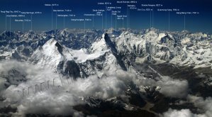
Mountains of Nepal
There are in total 1,310 mountain peaks over 5,000 meters high in Nepal as identified till this date. Among them 246 peaks have been located in western segment, 567 in central and 497 peaks in eastern segment.[1] According to the Government of Nepal, Ministry of Tourism, 414 mountain peaks have been opened for climbing expedition. Mountaineers have stepped on the top of 185 mountain peaks till this date. And there are still 229 mountain peaks to be conquered by human being.
Total number of summiteers to Mount Makalu are 434 till December 2014. Among the successful summiteers, 82 are from Nepal, 20 from Japan and the rest from other countries of the world.[2]
Mountaineering in 2016
According to the statistics of the Ministry of Tourism, 614 expeditioneers and mountaineers from 40 countries of the world, including Nepal, climbed successfully 23 mountain peaks during 2016 Spring season. Among them, 55 persons were the women and the rest 559 have been the male expeditioneers. Those 614 people who reached at the top of 23 mountains, of them 307 were the Nepalese and the rest 307 people have been the foreigners.
Actually, 746 expeditioneers had obtained permission to climb various mountains in this Spring season of 2016. But only 614 expeditioneers obtained the certificate of success. Among them, 40 mountaineers were successful to reach at the top of Makalu.[3]
While climbing Makalu, Da Tenji Sherpa of Jubing-1 of Solukhumbu District and Lakpa Wangel Sherpa from Makalu-5 of Sankhuwasabha District died at Camp II (6,700 m) after they complained of altitude sickness on the morning of 10 May 2016. They were part of an 11-member Amical Alpine Makalu Expedition-2016, locally managed by Thamserku Treks. The Sherpa duo died on the way to Camp-II, fellow climbers descended them after complaining of altitude sickness, as mentioned by Radha Sharma Bhattarai, Liaison Officer stationed in the region.[4]
Identity of Mount Makalu
Mount Makalu is located in the Mahalangur Himalayan Range, 14 km south-east of Mount Everest, on the border between Nepal and China. In local Limbu language this mountain is named as ‘Makalungma.’ In China, it is officially called as ‘Makaru.’
Makalu is the world’s fifth highest peak in the world rising to 8463 meters above mean sea level. This beautiful and impressive massive is situated east of Everest in the Khumbu region. Its size alone is impressive, but its perfect pyramidical structure with four sharp ridges makes this mountain all the more spectacular. However, Makalu is actually a double peak. The subsidiary peak rising just north of the main summit connected by a saddle is called Chomo Lonzo (7818m). It is interesting to note that the summit ridge is the demarcation point indicating the border between Nepal on the Southern side and Tibetan Autonomous Region (TAR) of China to the North.

The name of the mountain ‘Makalu’ was probably derived from the Sanskrit word Maha-Kala, which means ‘Big Black’ or Great Bleak’ or ‘The Giant’ and is a by name of Shiva– one of the most important gods of Hinduism that translates ‘Big Black.’ Shiva is sometimes an evil, cruel destroyer but at other times he tends to be gentle and kind-hearted. The mountain has another name in the local dialect- ‘Kumbha Karna’ which means ‘The Giant.’ Originally, Mount Makalu was registered as ‘Peak-XIII’ by Survey of India in 1849 AD.
Makalu has two notable subsidiary peaks. Kangchungtse, or Makalu-II (7678 m) lies about 3 km north-northwest of the main summit. Rising about 5 km north-northeast of the main summit across a broad plateau, and connected to Kangchungtse by a narrow, 7200 meter saddle, is Chomo Lonzo (7818 m). The summit ridge is the border between Nepal and Tibet.
Makalu is one of the harder eight-thousanders and is considered one of the most difficult mountains in the world to climb. The mountain is notorious for its steep pitches and knife-edged ridges. The final ascent of the summit pyramid needs technical rock climbing or ice climbing. Mount Makalu is a little bit dangerous as well. First five attempts were made before climbing this Makalu then only it was succeeded at the final.
Caravan route
The journey begins with a flight into Katmandu. From Kathmandu, it should catch a small plane to the small town of Tumlingtar in the north-east Nepal. From there it begins a trek along the Arun River to Khandbari. From Khandbari(1036meter), the real trekking starts to Manybhanjyang (1100 m)- Chichila (1700m)-Num (1600m)- Seduwa (1560m)- Tashi Gaun. Then it needs one day rest for acclimatization overnight. After rest, climbing starts from Tashi Gaun to Khongba-La (3760m)- Dobato (3700m)-Nebe Kharka (4320m)- Sherson (4630m)-Makalu base camp (4870m) to higher camp-2 (5160m). And then it needs near about 33 days period for climbing and descending. After descending, it may need one day for camp cleaning. Then the return starts from higher camp to Yak Kharka-Mumbuk-Tashi Gaon-Num-Chichira and Tumlingtar. It may need overnight rest at Tumlingtar. Finally, air flight should be taken to Kathmandu from Tumlingtrar air-field. Generally, it should have one day rest in Kathmandu and farewell Diner. And then one could transfer to International Airport and fly home. In such a way, it takes approximately 75 days round trip expedition period to climb on the top of Mount Makalu. The length of caravan route is 93.7 kilometer through Tumlingtar.

Climbing route
From the base camp, the climbing route can be divided into four parts. The bottom part begins at the base of the West Face at 5800 meters and limbs to the hanging ice-fall at 6100 meters to the right of ice-fall. The second part extends from the plateau above the ice-fall along 35 to 45 degree rock up to the bergshrund at 6500 meters. The next section is an ice-rock wall, 50 to 55 degrees steep, that extends to 7400 meters. The final part begins with a 70 to 75 degree rock pillar that leads to the West ridge at 8000 meters, and on to the summit (8463 m). The climbing route is 5.8 kilometer long.
Successful ascent
The French association with Makalu dates back to 1934 when they had been first permitted and later cancelled to climb the mountain. Their 1955 Makalu Expedition was the follow-up of their previous year’s successful reconnaissance. After leaving Base Camp on April 23, oxygen was used both on the march and and in camp above 6969 meters. Six days later, Camp-V was located beyond the col and weather remained fine. The first summit party of Jean Couzy and Lionel Terray established a subsidiary camp at about 7752 m and on 15 May 1955, trode upon the fragile cone of snow that forms the summit of Makalu. The ascent was repeated the following two days during which all the nine members of the assault party reached the summit ![5]
In this aspect, Makalu was first successfully climbed by Jean Couzy and Lionel Terray of a French expedition led by Jean Franco via the west face on 15 May 1955. Franco and G. Magnone summitted the next day, followed by Bouvier, S. Coupe, Leroux and A. Vialatte on the 17th May. This was an amazing achievement at the time to have the vast majority of expedition members summitted, especially on such a difficult peak.
However, the first attempt to climb on Makalu was made by an American team led by William Siri in the spring of 1954. The expedition was composed of Sierra Club members including Allen Steck, and was called the California Himalayan Expedition to Makalu. This was the first American mountaineering expedition to the Himalaya. They attempted the southeast ridge, but were turned back at 7100m by a constant barrage of storms. A New Zealand team including Sir Edmund Hillary was also active in the spring, but did not get very high due to injury and illness. Prior to Makalu’s first ascent in 1955, it was admired and studied by several Everest expeditions, but liked a lot to other giants in the Khumbu region. So Makalu was not attempted until the summit of Everest was first ascended in 1953.
Ang Chepal Sherpa is the first Nepali to climb Mount Makalu on 1 May 1978.[6] Among the women, Catherine Calhoun (USA) is the first lady to summit Makalu when she climbed the mountain on 18 May 1990. Labert Schaver (Austrian) is the first to solo ascent on 25 April 1981. Marjan Manfreda (former Yugoslavian) is the first person to reach the summit without using oxygen, on 6 October 1975.
Neighbourhood of Makalu
Makalu is a close neighbor of Mount Everest, lying in the northeast region of Nepal. Besides, the Makalu Barun National Park in the region offers some of the most spectacular scenery in the Himalayas. This region is blessed with an incredible diversity of natural beauty and culture.
Gurung, Rai and Sherpa are the main habitants in this region. Settlements of Rai, Sherpa, and Shingsawa (Bhotia) are farmers. Though economically poor and isolated, they retain a rich cultural heritage. They hold the key to the preservation of the unique biological and cultural treasures of the Makalu Barun area.
Makalu-Barun Valley is a Himalayan glacier valley situated at the base of Mt. Makalu in the Sankhuwasabha district of Nepal. This valley lies entirely inside the Makalu Barun National Park. The park of 2330 sq km is bordered by the Arun River in the east and the Sagarmatha National Park in the west. Barun Valley is a sanctuary for wild animals such as wolves, lynx, fox, falcon, red panda, musk deer, wild boar and the elusive snow leopard. Recognized for its tremendous diversity of plants, animals and people, the area contains 25 species of rhododendrons, 47 types of orchids, and 56 rare or endangered plants.[7] Barun Valley provides stunning contrasts, where high waterfalls cascade into deep gorges, craggy rocks rise from lush green forests, and colorful flowers bloom beneath white snow peaks. This unique landscape shelters some of the last pristine mountain ecosystems on earth. Rare species of animals and plants flourish in diverse climates and habitats, relatively undisturbed by human kind.
Makalu region, rich for natural paradise, includes beautiful mountains. The grand vistas include views of Mt. Makalu, Mt. Chamlang (7319m), Mt. Baruntse (7129m), Mera Peak (6654m) and other Nepal known peaks.

Administratively, Mount Makalu is located in Eastern Development Region, Sankhuwasabha District at Makalu Village Development Committee (VDC). Nearest settlement is Sadema, 41 kilometer far from the base camp. In the same way, the distance of nearest health post from the base camp is 48 km at Murmi Danda. Mountaineering royalty fee for the Nepali expeditioneers is Rs. 10000 in Spring, 5000 in Autumn and 2500 in Winter season. For the foreigners, the royalty rate is US$ 1,800 in Spring, 900 in Autumn and 450 in Winter season.
Nepal Mountaineering Association (NMA) with the collaboration of Government of Nepal, Ministry of Culture, Tourism and Civil Aviation was almost ready to observe the Diamond Jubilee Celebration of the first accent of Mount Makalu targeted to 15 May 2015. But it was not materialized, as there occurred a Great Earthquake having 7.9 Richter Scale in Nepal on 25 April 2015. Almost nine thousand people were killed. Near about five hundred thousand houses and buildings had been collapsed, and more than two hundred fifty thousand constructions have been partially damaged.
Eighteen mountaineers (4 foreigners and 14 Nepalis) were killed when a massive avalanche triggered by the devastating earthquake that struck Mt. Everest as well. The avalanche from the Pumori side buried the base camp where more than 500 climbers and over 600 support staff and guides were staying for acclimatisation in their camps. 61 expeditioneers had been injured due to sliding of glacier by the earthquake tremour on and around the base camp of Mount Everest. 30 injured climbers were being treated by doctors near the base camp.[8] Due to this earthquake disaster, the diamond jubilee celebration function of Mount Makalu was postponed. Now the function is going to be organised in mid-November 2016. Let us celebrate Mount Makalu Diamond Jubilee function in a great manner with grand success; so that it could attract the mountaineers and expeditioneers of all over the world for the development and expansion of mountain tourism of Nepal.
End Note:
[1] Harka Gurung (August 2004), Peaks and Pinnacles Mountaineering in Nepal, Nepal Mountaineering Association, Nagpokhari, Naxal, Kathmandu, Nepal: page 2 with a map.
[2] Mountaineering in Nepal Facts & Figures (June 2013), Ministry of Culture, Tourism & Civil Aviation, Tourism Industry Division, Bhrikuti Mandap, Kathmandu: page 142-52.
[3] Kantipur Daily, 14 July 2016
[4] The Himalayan Times Daily, 11 May 2016
[5] Harka Gurung (August 2004), Peaks and Pinnacles Mountaineering in Nepal, Nepal Mountaineering Association, Nagpokhari, Naxal, Kathmandu, Nepal: page 26-27.
[6] Mountaineering in Nepal Facts & Figures (June 2013), Ministry of Culture, Tourism & Civil Aviation, Tourism Industry Division, Bhrikuti Mandap, Kathmandu: page 141.
[7] Weekly Mirror (Magnificence of Makalu), 19 February 2016
[8] Himalayan Times Daily, 26 April 2015
Filed under: Uncategorized |

Leave a comment